This is what I do for fun (Spring Break, part 1)
For spring break this year, I decided I wanted to give the beach a rest and do something different. None of my friends were really enthused about going anywhere besides back down to Florida and I knew Colorado wasn't going to be an option either so I settled on doing some hardcore trail exploration. My goal: find and run as many new trails as possible. I'd be doing a lot of this on my own but I was hopeful to see some of my running friends along the way. So here's a brief day by day recounting of what I saw and did:


Day 1- Rebecca Mountain
The curious case of the disappearing trail
I started my run at the southern terminus of the Pinhoti trail about 11 miles south west of Bull's Gap, the location of the mile 90 aid station from the Pinhoti 100 race in November. As per some good directions given to me by Josh Kennedy, I meandered my way through some serious back roads and eventually found the inconspicuous trail head and headed off. (At one point my Garmin navigator only displayed the little car, a solid white backdrop and above it read "Heading East" where it would normally display the name of the road you are on.)
The first few miles would consisted of some little used winding trails and old, forgotten jeep roads that would eventually take me up to the ridge line where the best section of trail is. Along the way I saw quite a bit of wild life. It was about 1700 and dusk was approaching, the perfect time to spot the wood's inhabitants. At one point I spotted an opossum bumbin down a hillside comin straight towards me like I wasn't there. The squirrels, deer, and turkey I spotted later instead hightailed it out of there whenever I got close. I don't suspect these guys get a lot of human interaction.
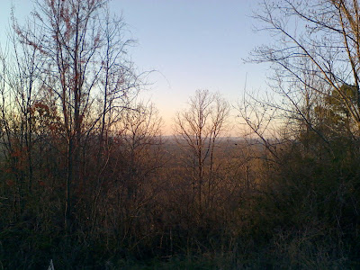
I savored the great trails on the top of the ridge line and was treated with some nice views between the trees whenever I glanced left or right. I stopped a time or two just to take it in.
When my Forerunner told me I hit 1 hour of running, I turned around and headed back. On the way back down the ridge, while I was tackling some switchbacks, the failing sunlight no longer offered enough illumination to guide my way so I took my PTZEL headlamp out of my large camelbak and continued on. Though the trails looked suddenly very different, seeing them in the opposite direction and with no overhead light, I was able to find my way back relatively well. Then came the part where I'm pretty sure I may have stumbled into an invisible teleporter and found myself at an intersection I didn't recognize. At that point, I retraced my steps about a half mile back, looking everywhere for the blue blazes that I'd been following this whole time, but found nothing. Down and back on this trail I walked, rechecking my map, and found no sign whatsoever of the section of trail that I should have been running down.
The air was black as pitch, the little sun on my head only providing a tunnel of vision that pierced the darkness immediately to my front. An owl ho-hooed, and a night train rushed across some nearby tracks, and I had a few words with Jesus. I knew the general location of my car but straight up couldn't find any blue blazes. I finally just decided to go back to that intersection and use my best judgement as to which was I was supposed to go.
The gravel road that crunched under my feet started leading downward. I figured I had about another mile, maybe less, to go before I'd be close to my car. This road had to lead somewhere. I spotted an overturned boat to my left, which was extremely reassuring as I remember seeing it on the way out. A minute later I came upon another intersection and realized this was very familer. I saw two reflective...somethings down the road to my left, figured I check that out in a second, and turned back the way I had come to contemplate at what point in my run I had hit this intersection so I could gain my bearings. It was then I realized I was here at the very beginning of my run. I turned again and realized those two reflective things were the headlights of my car.
Baffled, befuzzled, and otherwise bamboozled that somehow I had skipped a good mile of trail and was already back, I thanked the big man upstairs and hugged my car before taking off my camelbak and getting out of there.

The view from the ridge line
Day 2-
Amphibious Running
This time last year I was running mindless laps around a park in Decatur setting a state record for my age. Miserable races like this are a lot like playing a game of Risk: If you haven't done it in a while and some of your friends announce that they are going to get together and do it again, you're all for it, but by the time it's over you feel like you don't want to do it again for a long while. Well, the suckiness of last year's run hadn't worn off on me so I opted out. I did, however, head over there today to check out the festivities and see some old friends.
I chatted with Blake, John, and Rob about possible running venues in the Joe Wheeler Wildlife Refuge in the surrounding area. After I got some instructions, I drove over where I was instructed and parked at the end of a dead end road. From there, a dirt road heads off to the right into the refuge toward the Tennessee river. After running through some pastures and past some pickups towing boats and dogs, I came across the first flooded road. Rob had mentioned I might see some of this and I would find out later that this little stretch of 6 to 10 inch deep water was just a foreshadowing of what I would encounter later. I plowed down the flooded road as two confused (maybe amused?) fishermen in a flat-bottom not 20 meters to my left looked on as a goofy runner splashed through the water.
I made my way south along some more jeep road, getting closer and close to the river proper. The jeep road continued quite a ways as I passed under I-65 and ran with the river to my left. I could see the factories of Decatur about 5 miles across the expansive water. About three miles later and this jeep road still showed no signs of ending nor did I come across and intersection of any kind. Some bikers were heading towards me and I went ahead and asked for directions. One of them promised that about a half mile down the road, the "Eagle's Nest" jeep road bears off to the right and connects back up with where I had come from, confirming what I had heard from Rob earlier.
2.5 miles later, I finally found that intersection. That biker doesn't understand how far a mile is I guess. I took a right and headed back. I figured I shouldn't be more than maybe 5 miles away from my car. Just cruisin in from here, right?
Another mile down this wooded double track, I came upon some more flooded road. My feet were already wet so I simply went full steam ahead. The water was only as deep as my ankles...mid-calf...knee...thigh. I stopped and turned around. I didn't know how deep this little lake I found before me was. I had a decision to make. Turing around meant I'd have to take the long way back, an additional 8 miles at the least. I was already about 10 miles into my run and hadn't planned on going that far, nor did I have enough water. So, throwing caution to the wind and hoping there were no snakes nearby I stomped forward. The road wasn't visible for as far as I could see for the water concealing it. There was simply no other way around. A steep berm was off to my left and nothing but swampy wilderness was to my right. The water was at my stomach now and rising. I kept pushing forward, slapping a stick on the water's surface to scare away and potential poisonous critters. The the road that was underneath me suddenly dropped off. A huge pot hole, maybe? Now I was swimming, the water up to my neck. The shock of the chilly water took my breath away for a moment. I kicked forward and my feet eventually found solid ground again as I thrust myself out. The water was still at my waist but it looked like it was getting shallower.
By the time it was all said and done, I had to go through about 5 more very flooded sections of road before I finally made it out of there but none quite as deep as that first section.
Thoroughly soaked, I ran down the last section of packed dirt road to my awaiting Lancer.
From there, I headed back to Delano Park to meet up with my parents who had ridin the Harley over from the house. After saying good-bye to my favorite running people my parents and I drove over to a local Asian buffet. I demolished some Mongolian bbq, sushi, and a couple things that I only kinda knew were edible. Fully satiated, back at the house I dropped into bed for a needed night's rest.

This is just a little taste of what I got to swim through
Day 3/4-
Got sick on Sunday and took the day off. Monday I picked up a pair of New Balance Minimus, the road version and the trail version. I'll have a review of both these shoes here soon. In a nutshell, they're pretty great.
Day 5
Natchez Trail
I've made several visits to Franklin, TN to see family and it's been a long time since I was here last. Every time I'm here, I always want to hit up the nearby trails but never really get a chance. To quench my curiosity, I decided to commit a few of my spring break days to do some more exploring.
The full Natchez trail runs from southwest Mississippi up to Nashville 444 miles away. Back in the day, this trail ran through the Creek and Chickasaw Indian territories and provided passage for natives and pioneers alike, on horseback and foot. Today not a whole lot has changed. While the pioneering and Indians are gone, this trail serves essentially the same purpose. Though parts of the original Natchez trail has been paved over or otherwise disappeared from lack of use, there are still plenty of trail heads along the historic Natchez Parkway.
The northern most trail head is located about 10 miles southwest of Franklin and was the perfect spot for me to start. I parked my car in an empty lot on a very cloudy day and headed south. The trail was pretty muddy in some sections from the rain it received yesterday and all the hoof prints from horse traffic didn't help much either but by and large, it was pretty runnable.
The trail never takes its users far from the Parkway but I was still able to get that feeling that no one could find me pretty much the whole time, which is a good thing.
I crossed rivers and back roads a few times every mile and enjoyed the scenic, timeless Tennessee country side. The trail rolled with the terrain and had a few short steep areas at times but I was able to run the whole way.
On the way out, I really didn't look at my Garmin at all until about an hour and a half after I started. I saw that I had gone 10 miles and wanted to keep going but had to respect the fact that I had a return trip to make. I kept telling myself, "just after this corner, or around that bend" but eventually had to realize that any more than 20 miles today and I'd be beat by the time tomorrow's run came around.
Not a whole lot more to say about this trail, really. Nice terrain and indeed very scenic. I'll leave the rest of this space for some pics I took with my phone.


Comments
Post a Comment